
What's mainly wrong with society today is that too many Dirt Roads have been paved.
There's not a problem in America today, crime, drugs, education, divorce, delinquency that wouldn't be remedied, if we just had more Dirt Roads, because Dirt Roads give character.
People that live at the end of Dirt Roads learn early on that life is a bumpy ride.
That it can jar you right down to your teeth sometimes, but it's worth it, if at the end is home...a loving spouse, happy kids and a dog.
We wouldn't have near the trouble with our educational system if our kids got their exercise walking a Dirt Road with other kids, from whom they learn how to get along.
There was less crime in our streets before they were paved.
Criminals didn't walk two dusty miles to rob or rape, if they knew they'd be welcomed by 5 barking dogs and a double barrel shotgun.
And there were no drive by shootings.
Our values were better when our roads were worse!
People did not worship their cars more than their kids, and motorists were more courteous, they didn't tailgate by riding the bumper or the guy in front would choke you with dust & bust your windshield with rocks.
Dirt Roads taught patience.
Dirt Roads were environmentally friendly, you didn't hop in your car for a quart of milk you walked to the barn for your milk.
For your mail, you walked to the mail box.
What if it rained and the Dirt Road got washed out? That was the best part, then you stayed home and had some family time, roasted marshmallows and popped popcorn and pony rode on Daddy's shoulders and learned how to make prettier quilts than anybody.
At the end of Dirt Roads, you soon learned that bad words tasted like soap.
Most paved roads lead to trouble, Dirt Roads more likely lead to a fishing creek or a swimming hole.
At the end of a Dirt Road, the only time we even locked our car was in August, because if we didn't some neighbor would fill it with too much zucchini.
At the end of a Dirt Road, there was always extra springtime income, from when city dudes would get stuck, you'd have to hitch up a team and pull them out.
Usually you got a dollar...always you got a new friend...at the end of a Dirt Road!
~by Paul Harvey~
Saturday, March 22, 2008
Thursday, March 20, 2008


Quote
"Take care to get what you like or
you will be forced to like what you get."
(George Bernard Shaw)
you will be forced to like what you get."
(George Bernard Shaw)
Wednesday, March 19, 2008
Stone Mountain Natural History
Natural History
Stone Mountain sits on the western edge of a large belt of Lithonia Gneiss granite although the younger intrusive granite that comprises the mountain is entirely different from Lithonia granite. Rising to a height of 1,683 feet above sea level (roughly 650-750 feet above the surrounding Georgia Piedmont, depending on where it is measured), it is visible from Kennesaw Mountain to the west, Amicalola Falls State Park to the north and Mount Yonah to the northeast.
Technically known as a pluton, the mountain was formed during the complex folding and faulting that created the Blue Ridge Mountains, although Stone Mountain is not part of that range. The magma that created Stone Mountain was formed deep inside the earth, then forced its way out of the earth's molten center. Before the molten rock hit the air it stopped, initially forming the west side of the "pluton." Successive attempts at eruption (breaking through to the surface of the earth) also failed, but added to the size of the dome from west to east. Once the pluton was formed it began to cool. This occurred during the Alleghenian Orogeny, a massive collision of tectonic plates perhaps 350 million years ago.
Geologists, however, are stumped as to how this enormous rock (the largest known granite formation) became exposed. Some believe that the entire Georgia Piedmont region was higher than the mountain and over time, erosion simply wore the dirt and metamorphic stone surrounding the mountain away. Others believe that the area was flooded after the formation of the mountain and the water eroded the surrounding material. A third theory includes post-formation geological events (primarily earthquakes).
Analysis of the rock reveals that the magma that created the pluton was comprised of quartz, feldspar, microcline and muscovite with smaller amounts of biotite and tourmaline. Embedded in the granite are pieces of biotite gneiss and amphibolite
There are many ways that rock changes over time. The two most commonly associated with Stone Mountain are exfoliation and erosion. Granite is normally exfoliated in sheets, along the same natural lines that it is quarried. These lines, known technically as joints, run throughout Stone Mountain. They are expanded the erosive forces of heat, cold, weather (mostly wind and rain), gravity and plant life or any combination of these elements. Once a sheet on the surface as been exfoliated and the sheet of rock beneath it is exposed the process begins again.
The same erosive elements that open the joints in the rock work on the surface as well, but at a much slower rate. Erosion, for example, creates the vernal pools which form on level surfaces of the mountain. These pools are the indentations up to a few feet wide that fill with water during the spring (vernal is another word for spring). Many will remain damp or filled with water well into the summer, especially larger pools. A little shade from a scrub pine helps the pools hold the water long as well. Vernal pools are one type of weathering pits on the mountain. Watch for larger indentations, several feet wide, where trees and schrubs have taken hold and grow, adding their pressure to the eroding mountaintop.
Vernal pools play an important role in life at the top of the seemingly barren mountain. Just as in a desert, life at the top of Stone Mountains depends on the water available in the vernal pools. When the summer is wet the pools, ranging in size from several inches to several feet, may hold water most of the year. During drought years the pools can be dry from June until October. While larger mammals like squirrel and fox rely on the water for drinking other flora and fauna depend on the water for life.
Two types of shrimp frequently inhabit these pools, fairy shrimp and clam shrimp, as well as a unique variety of red moss.
Water that falls on the mountain that is not captured in these pools also plays a role in the evolution of the mountain. On the sides of the mountain lichen and moss come to life after a rain, but create a treacherous environment for hikers, especially on the Mountaintop Trail. As the water cascades down the sides of Stone Mountain it forms small streams near the base, creating a cooler, more diverse forested environment.
Stone Mountain's slopes offer a haven for a variety of birds (including migratory species in the Spring and Fall) and various small animals. Among the common birds are Hoot Owl, Red-tailed Hawk, Wood Ducks, Mallard, Great Blue Herons and various egrets. One overlooked species is the peregrine falcon, sometimes called a duck hawk, now off the endangered species list and an occasional visitor to the mountain. Mammals that inhabit the mountain include red fox, bobcat, grey squirrel, rabbits and deer.
Tucked in the crevices and outcroppings of rock that make up the majority of Stone Mountain's surface, a wide range of plant life makes its home. Most famous is the Stone Mountain Yellow Daisy (also known as the Confederate Daisy), found by Reverend Thomas Porter in 1846. The plant lends its name to the Yellow Daisy Festival, one of the most popular events in the Southeast United States.
Flowering yucca is also found on the mountain, as well as other flora including various species of pine tree, especially stunted loblolly, cactus, and a few small hardwoods.
Source: Larry Worthy, Editor-in-chief exclusively for About North Georgia
Tuesday, March 18, 2008
Braselton, GA
Braselton is a town in Barrow, Gwinnett, Hall, and Jackson counties in the U.S. state of Georgia, about 40 miles (64 km) northeast of Atlanta. As of the 2010 census, the town had a population of 7,511, with an estimated population in 2012 of 7,875.

Chateau Elan
The Gwinnett and Barrow County portions of Braselton are part of the Atlanta–Sandy Springs–Marietta, GA, Metropolitan Statistical Area, and the Hall County portion is part of both the Atlanta and Gainesville, GA Metropolitan Statistical Areas. The remaining Jackson County portion of Braselton is not part of any core based statistical area.
 BETTIS SPEAKS ABOUT CITIES’ PAST
Robbie
Bettis, owner of the Braselton Antique Mall and Ye Olde Station
antiques in Hoschton, shows a photo of the first post office in
Hoschton. Bettis talked to the Friends of the Braselton-West Jackson
Library, Inc. during the group’s annual meeting last week about the
histories of Braselton and Hoschton.
BETTIS SPEAKS ABOUT CITIES’ PAST
Robbie
Bettis, owner of the Braselton Antique Mall and Ye Olde Station
antiques in Hoschton, shows a photo of the first post office in
Hoschton. Bettis talked to the Friends of the Braselton-West Jackson
Library, Inc. during the group’s annual meeting last week about the
histories of Braselton and Hoschton.
A history of two cities
Group learns about histories of Braselton, Hoschton
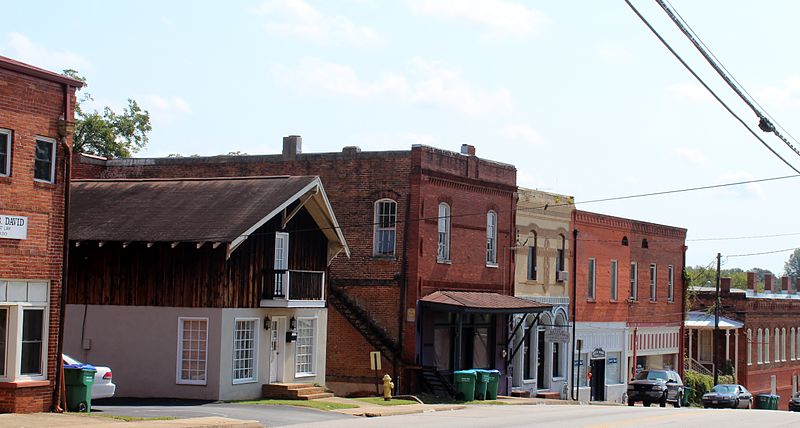
Braselton and Hoschton may seem today to be molding their own futures, but their pasts are tied to one another by a few things — including a railroad, former American Indian trails and family blood.
Robbie Bettis, owner of the Braselton Antique Mall and Ye Olde Station antiques in Hoschton, told members of The Friends of Braselton-West Jackson Library, Inc. last week about the two cities’ histories.
Bettis’ book, “Passing,” which explains how the small town-atmosphere is dying, is expected to be published this summer.
Braselton and Hoschton grew around the Mulberry River, which is the modern-day border between Jackson and Barrow counties.

Mayfield Dairies Visitors Center
Indians used the path of the Mulberry River for their trails, which later became the routes for Ga. 211 and Ga. 53, Bettis said. An Indian burial mound is located off the banks of the Mulberry River on Hog Mountain Road in Barrow County.
Hog Mountain Road — which is also known as Peachtree Road and Covered Bridge Road — was a vital road in the founding of Hoschton, Bettis added.
And the beginning of Hoschton can be traced to 1813, when Henry Hosch moved from South Carolina to Walton County.
Hosch bought land from several Northeast Georgia counties, including Jackson County in the 1840's, Bettis said. He married Matlida Camp in 1837, and their first daughter, Susan, was born in Walton County. Eight children would be born in Hoschton.
Lt. Hosch volunteered to fight in the Civil War following a recruitment gathering at Rockwell Church. He immediately left for battle without saying good-bye to his family, Bettis said.
Hosch died in Richmond, Va. in 1862, following an illness. He is buried in a copper coffin in the Hoschton cemetery.
In 1867, Susan Hosch married William Harrison Braselton, who was considered “beneath her,” Bettis said. Susan was trained in the fine arts, while William Harrison was a “dirt farmer,” she said.
It was soon after that controversial wedding took place that the two cities truly began to establish their townships.
Susan Hosch’s brothers, John and Russell, opened the Hosch Store when they were 15 and 10, respectively. A post office opened in the town in 1878 and a school began operating in 1881.
THE RAILROAD COMES TO TOWN
The town didn’t receive its name until a railroad company wanted to lay track in the growing village, Bettis said. The town’s founding brothers — John Robert (J.R.), Russell Angel (R.A.), Henry Andrew and William — divided Hoschton into 3/4-acre lots, starting from the new train station.
“The railroad became an extremely important thing for towns and cities,” Bettis said.
The railroad service between Gainesville to Social Circle began operating through Hoschton in 1882. Service ended in 1947. During that time, passengers may have boarded the train at the Hoschton Depot, while merchandise was delivered at a stop at the Braselton Brothers Store.
That store’s roots began in 1887, when John Oliver Braselton — one of three sons of William Harrison and Susan Braselton — starting selling items to field hands. In 1904 the “Three Bs,” brothers John Oliver, Green and Henry, opened a brick store.
Business was so good for the Braselton Brothers Store, that it was expanded in 1910 and a bank was added in 1911, Bettis said. The brothers also built a cotton gin, enterprise flour and grist mill, blacksmith shop, co-op fertilizer plant and saw mill.
And business was doing well in Hoschton, too.
In 1898, the city had 10 stores, two drug stores, two blacksmith shops, a millinery shop, a planning mill, a shoe shop, a wood working shop, a tannery and harness shop, a gristmill, four boarding houses, a soda bottling shop and a cotton gin.
DOCTORS FLOURISH IN CITY
The medical profession also lured more people to Hoschton, Bettis said.
During its early history, the city had numerous doctors, including William “Bud” DeLaPerriere, Earnest DeLaPerriere, J.W. Darby, Ralph Freeman, L.C. Allen, and Myron Allen.
Dr. L.C. Allen and his son, Myron, opened the Allen Clinic in the 1930's (which is today located on the corner of Peachtree Road and Ga. 53). The clinic severed numerous patients throughout Northeast Georgia, including the “mountain folks” who would camp on the clinic’s yard until visited by a doctor, Bettis said.
L.C. Allen’s clinic once operated in the city square in the building that is today city hall. He lived in an antebellum house on White Street that has seen its use as a tea house in recent years.
Myron Allen, on the other hand, became the talk of Hoschton when he accidentally shot his wife in 1936. Allen was still practicing on patients before he was acquitted of his wife’s death by a Jackson County jury, Bettis said.
Hoschton also owes its history to another family who settled in West Jackson.
The DeLaPerriere family — which has a “French Connection” — first moved to Jackson County in the early 1880's.
In 1785, the Georgia General Assembly gave Count Charles Hector Theodat D’Estaing 20,000 acres in what would later become Jackson and Banks counties. The land gift was the legislators’ way of thanking D’Estaing for his assistance in Savannah during the American Revolution.
But, D’Estaing probably never saw his Georgia land — he was beheaded in 1794 during the French Revolution. The 20,000 acres was given to his sister, whose first husband was General Ange DeLaPerriere. Their son, Ange, is considered the ancestor of the present DeLaPerriere family.
Ange DeLePerriere was a doctor, and state representative and senator. He settled near the present-day spot of West Jackson Middle School and is believed to be buried on the Traditions of Braselton property, Bettis said.
HISTORIC HOUSES
In the early 1900's, the three Braselton brothers built their homes, which are still occupied today.

The Story of the great house on the corner
John Oliver Braselton’s house, which was built in 1904, is located on the corner of Ga. 53 and Ga. 124 and is today the home of former mayor Henry Edward Braselton, John Oliver’ son.
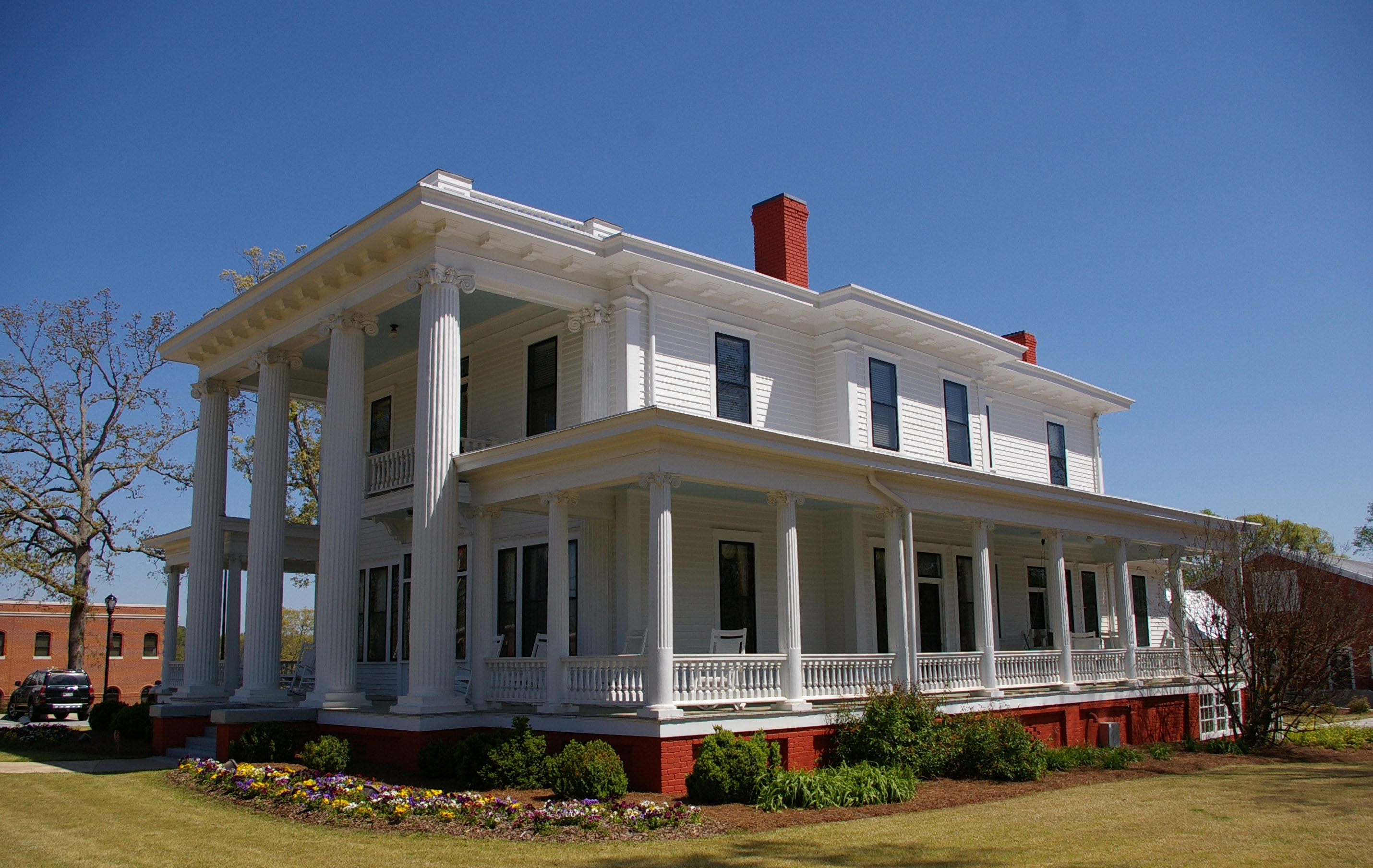
Henry Braselton’s house was built and in 1910 and is now the Braselton Town Hall. The house was extensively remodeled in the late 1990s and Bettis described the building as “one of the most beautiful city halls in the state.”

Braselton-Stover House
In 1918, Green Braselton built his house on Ga. 53. Today, the Braselton-Stover House operates from the building.
The Hosch brothers also built their homes on their land. John Hosch’s house, which was built on Ga. 53, is now occupied by Prudential Georgia Realty.
A real estate deal in 1990 brought national media to Braselton, when the Basinger Group — which included actress Kim Basinger — purchased the town for $20 million. The town was first listed on the real estate market in 1980 for $17 million, Bettis said. Braselton was sold again to a group of developers in 1994.
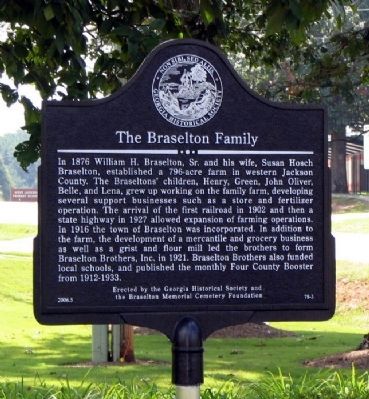
The Braselton Family
Inscription. In
1876 William H. Braselton, Sr. and his wife, Susan Hosch Braselton,
established a 796-acre farm in western Jackson County . The Braseltons’
children, Henry, Green, John Oliver, Belle, and Lena , grew up working
on the family farm, developing several support businesses such as a
store and fertilizer operation. The arrival of first the railroad in
1902 and then a state highway in 1927 allowed expansion of farming
operations. In 1916 the town of Braselton was incorporated. In addition
to the farm, the development of a mercantile and grocery business as
well as a grist and flour mill led the brothers to form Braselton
Brothers, Inc. in 1921. Braselton Brothers also funded local schools,
and published the monthly Four County Booster from 1912-1933.
THE ‘WOG’
And local history stories wouldn’t be complete without a mysterious figure — in this case, the “Wog.”
“Every great story has to have a creature,” Bettis joked.
An early history book of Jackson County recounts that the “Wog” was supposedly seen lurking on Hog Mountain Road in Hoschton and near Jug Tavern (which is now Winder).
According to one written account, the “Wog” was described by locals as a creature with a “bear-like head,” with black hair “ugly lips,” a forked tongue and a large tail in constant motion. Like a local “boogie-man” figure, it was common for parents to tell their children about the “Wog,” Bettis said.
“Well, I hate to tell everybody, but it was a legend,” she said.
Source: mainstreetnews.com
 It's
been quietly sitting in the heart of downtown Braselton for probably a
century - but little is known about the former state-of-the-art mill.
Located at the intersection of Ga. Hwy. 53 and Frances Street - across
from Northeast Georgia Bank - the Enterprise Flour and Grist Mill in
Braselton was once considered one of the most modern operations for
converting grain into flour.
It's
been quietly sitting in the heart of downtown Braselton for probably a
century - but little is known about the former state-of-the-art mill.
Located at the intersection of Ga. Hwy. 53 and Frances Street - across
from Northeast Georgia Bank - the Enterprise Flour and Grist Mill in
Braselton was once considered one of the most modern operations for
converting grain into flour.
 While
no one knows for certain when the three-story wooden building was
constructed, writing from an old photo says the roller mill was built
around 1900. Most likely, it was one of several businesses started
around the turn of the 20th century by the town's founding brothers -
the "3Bs" - who established the Braselton Brothers Store, just one block
from the mill. It survived a tornado that hit the town in 1920, but
destroyed the first Braselton High School a block away.
While
no one knows for certain when the three-story wooden building was
constructed, writing from an old photo says the roller mill was built
around 1900. Most likely, it was one of several businesses started
around the turn of the 20th century by the town's founding brothers -
the "3Bs" - who established the Braselton Brothers Store, just one block
from the mill. It survived a tornado that hit the town in 1920, but
destroyed the first Braselton High School a block away.
 An
article from The Atlanta News in 1907 describes the first full roller
process flouring mill in Northeast Georgia. "Their complete Murray
ginning system is up to date and has a fine patronage, ginning from 800
to 1,000 bags every season," according to the article. "It is always a
place of push and system and it infuses new life in one to visit there
and see the wonderful accomplishments of these young men in the past few
years."
An
article from The Atlanta News in 1907 describes the first full roller
process flouring mill in Northeast Georgia. "Their complete Murray
ginning system is up to date and has a fine patronage, ginning from 800
to 1,000 bags every season," according to the article. "It is always a
place of push and system and it infuses new life in one to visit there
and see the wonderful accomplishments of these young men in the past few
years."
 A
1939 article from The Jackson Herald said the building contained "a
wheat mill with the latest and best machinery that money can buy."
Herbert B. "Kit" Braselton, 89, remembers installing equipment in the
roller mill - where self-rising flour was produced. "That was unusual
for a rural mill to make self-rising flour," he said. The Braselton mill
produced two brands, "Three Bs" and "Fast Flyer."
A
1939 article from The Jackson Herald said the building contained "a
wheat mill with the latest and best machinery that money can buy."
Herbert B. "Kit" Braselton, 89, remembers installing equipment in the
roller mill - where self-rising flour was produced. "That was unusual
for a rural mill to make self-rising flour," he said. The Braselton mill
produced two brands, "Three Bs" and "Fast Flyer."
 "People
came from great distances for their wheat that they ground," Kit
Braselton said. The mill had a daily capacity of 50-70 barrels of flour
and 300 bushels of meal, according to the 1907 The Atlanta News article.
Today, nobody in the town knows how the equipment in the Braselton mill
was operated, said town manager Jennifer Dees.
"People
came from great distances for their wheat that they ground," Kit
Braselton said. The mill had a daily capacity of 50-70 barrels of flour
and 300 bushels of meal, according to the 1907 The Atlanta News article.
Today, nobody in the town knows how the equipment in the Braselton mill
was operated, said town manager Jennifer Dees.
 Robbie
Bettis, who has written a book about the history of Braselton and
Hoschton, said it is believed to be the last mill in Georgia to make
self-rising flour. The mill probably stopped operation in the 1950s.
"It's really in excellent shape for something as old as it is," she
said. Inside, it looks as though the old mill could start running again -
the equipment remains virtually untouched, the belts appear strong and
wheat dust from the last run decades ago is scattered throughout the
building.
Robbie
Bettis, who has written a book about the history of Braselton and
Hoschton, said it is believed to be the last mill in Georgia to make
self-rising flour. The mill probably stopped operation in the 1950s.
"It's really in excellent shape for something as old as it is," she
said. Inside, it looks as though the old mill could start running again -
the equipment remains virtually untouched, the belts appear strong and
wheat dust from the last run decades ago is scattered throughout the
building.
 It
is believed that John Braselton, who once lived in the residence that
is now town hall, was the last person to operate the mill. A tour of the
building reveals mementos of the decades from Braselton. There's
graffiti with a Bible verse written on a wall with a date of 1943. Food
boxes from the former Dado's Foods restaurant, which was demolished in
2004 to make way for a new Northeast Georgia Bank branch, litter the
interior near a few windows. And there's plenty of beer cans from brands
once popular in the 1970s.
It
is believed that John Braselton, who once lived in the residence that
is now town hall, was the last person to operate the mill. A tour of the
building reveals mementos of the decades from Braselton. There's
graffiti with a Bible verse written on a wall with a date of 1943. Food
boxes from the former Dado's Foods restaurant, which was demolished in
2004 to make way for a new Northeast Georgia Bank branch, litter the
interior near a few windows. And there's plenty of beer cans from brands
once popular in the 1970s.
 For
now, town officials plan to spend 2010 stabilizing the building and
weatherizing it. The roof was replaced several years ago. The building
won't be affected by the upcoming realignment of Ga. Hwy. 124 behind the
Braselton Brothers Store, although an old telephone building near the
structures will be relocated. The town now owns the building, but
officials haven't decided what - if anything - to do with the interior
of the old mill. "The exterior is relatively easy, but we've got to
figure out what to do with the interior," said town manager Dees.
Another -and more well known - grist mill, Sells Mill, was opened in
1914. Jackson County bought the mill's property located on Jackson Trail
Road in Hoschton in 2000 for a park and renovated the mill in 2005.
For
now, town officials plan to spend 2010 stabilizing the building and
weatherizing it. The roof was replaced several years ago. The building
won't be affected by the upcoming realignment of Ga. Hwy. 124 behind the
Braselton Brothers Store, although an old telephone building near the
structures will be relocated. The town now owns the building, but
officials haven't decided what - if anything - to do with the interior
of the old mill. "The exterior is relatively easy, but we've got to
figure out what to do with the interior," said town manager Dees.
Another -and more well known - grist mill, Sells Mill, was opened in
1914. Jackson County bought the mill's property located on Jackson Trail
Road in Hoschton in 2000 for a park and renovated the mill in 2005.
 The
photos below were a part of the same newspaper article. As you can see
from the photo above, the mill is not open to the general public.
The
photos below were a part of the same newspaper article. As you can see
from the photo above, the mill is not open to the general public.


 And
one last photo that I took on this breezy January morning, 2010. It's
nice to know that this old mill will be around for a long time to come
(with a lot of work).
And
one last photo that I took on this breezy January morning, 2010. It's
nice to know that this old mill will be around for a long time to come
(with a lot of work).

In 1989 actress and Georgia native Kim Basinger bought the town for $20 million, intending to turn it into a tourist destination. Five years later, on the eve of personal bankruptcy, she and her partners sold the town at a large loss.
 The town of Braselton, incorporated in 1916, occupies thirty-four square miles in northeast Georgia, spreading across Barrow, Gwinnett, Hall, and Jackson
counties. In 1876 William Harrison Braselton bought 800 acres of land
and built a plantation on it. His eldest son, William Henry, served as
the first mayor of Braselton. Descendents of the Braseltons continued to
serve on the city council until 2001, when Henry Edward Braselton lost
the title of mayor to Pat Graham.
The town of Braselton, incorporated in 1916, occupies thirty-four square miles in northeast Georgia, spreading across Barrow, Gwinnett, Hall, and Jackson
counties. In 1876 William Harrison Braselton bought 800 acres of land
and built a plantation on it. His eldest son, William Henry, served as
the first mayor of Braselton. Descendents of the Braseltons continued to
serve on the city council until 2001, when Henry Edward Braselton lost
the title of mayor to Pat Graham.

 Eventually, Braselton
expanded its boundaries and attracted major companies, turning the
small town into a booming residential and manufacturing area. The
Mayfield Dairy Visitors Center opened in 1997, Panoz Auto Development
Company opened in 1999, and Haverty's Distribution Center opened in
2002.
Eventually, Braselton
expanded its boundaries and attracted major companies, turning the
small town into a booming residential and manufacturing area. The
Mayfield Dairy Visitors Center opened in 1997, Panoz Auto Development
Company opened in 1999, and Haverty's Distribution Center opened in
2002.
Chateau Elan
The Gwinnett and Barrow County portions of Braselton are part of the Atlanta–Sandy Springs–Marietta, GA, Metropolitan Statistical Area, and the Hall County portion is part of both the Atlanta and Gainesville, GA Metropolitan Statistical Areas. The remaining Jackson County portion of Braselton is not part of any core based statistical area.
BETTIS SPEAKS ABOUT CITIES’ PASTA history of two cities
Group learns about histories of Braselton, Hoschton
Braselton and Hoschton may seem today to be molding their own futures, but their pasts are tied to one another by a few things — including a railroad, former American Indian trails and family blood.
Robbie Bettis, owner of the Braselton Antique Mall and Ye Olde Station antiques in Hoschton, told members of The Friends of Braselton-West Jackson Library, Inc. last week about the two cities’ histories.
Bettis’ book, “Passing,” which explains how the small town-atmosphere is dying, is expected to be published this summer.
Braselton and Hoschton grew around the Mulberry River, which is the modern-day border between Jackson and Barrow counties.
Mayfield Dairies Visitors Center
Indians used the path of the Mulberry River for their trails, which later became the routes for Ga. 211 and Ga. 53, Bettis said. An Indian burial mound is located off the banks of the Mulberry River on Hog Mountain Road in Barrow County.
Hog Mountain Road — which is also known as Peachtree Road and Covered Bridge Road — was a vital road in the founding of Hoschton, Bettis added.
And the beginning of Hoschton can be traced to 1813, when Henry Hosch moved from South Carolina to Walton County.
Hosch bought land from several Northeast Georgia counties, including Jackson County in the 1840's, Bettis said. He married Matlida Camp in 1837, and their first daughter, Susan, was born in Walton County. Eight children would be born in Hoschton.
Lt. Hosch volunteered to fight in the Civil War following a recruitment gathering at Rockwell Church. He immediately left for battle without saying good-bye to his family, Bettis said.
Hosch died in Richmond, Va. in 1862, following an illness. He is buried in a copper coffin in the Hoschton cemetery.
In 1867, Susan Hosch married William Harrison Braselton, who was considered “beneath her,” Bettis said. Susan was trained in the fine arts, while William Harrison was a “dirt farmer,” she said.
It was soon after that controversial wedding took place that the two cities truly began to establish their townships.
Susan Hosch’s brothers, John and Russell, opened the Hosch Store when they were 15 and 10, respectively. A post office opened in the town in 1878 and a school began operating in 1881.
THE RAILROAD COMES TO TOWN
The town didn’t receive its name until a railroad company wanted to lay track in the growing village, Bettis said. The town’s founding brothers — John Robert (J.R.), Russell Angel (R.A.), Henry Andrew and William — divided Hoschton into 3/4-acre lots, starting from the new train station.
“The railroad became an extremely important thing for towns and cities,” Bettis said.
The railroad service between Gainesville to Social Circle began operating through Hoschton in 1882. Service ended in 1947. During that time, passengers may have boarded the train at the Hoschton Depot, while merchandise was delivered at a stop at the Braselton Brothers Store.
That store’s roots began in 1887, when John Oliver Braselton — one of three sons of William Harrison and Susan Braselton — starting selling items to field hands. In 1904 the “Three Bs,” brothers John Oliver, Green and Henry, opened a brick store.
Business was so good for the Braselton Brothers Store, that it was expanded in 1910 and a bank was added in 1911, Bettis said. The brothers also built a cotton gin, enterprise flour and grist mill, blacksmith shop, co-op fertilizer plant and saw mill.
And business was doing well in Hoschton, too.
In 1898, the city had 10 stores, two drug stores, two blacksmith shops, a millinery shop, a planning mill, a shoe shop, a wood working shop, a tannery and harness shop, a gristmill, four boarding houses, a soda bottling shop and a cotton gin.
DOCTORS FLOURISH IN CITY
The medical profession also lured more people to Hoschton, Bettis said.
During its early history, the city had numerous doctors, including William “Bud” DeLaPerriere, Earnest DeLaPerriere, J.W. Darby, Ralph Freeman, L.C. Allen, and Myron Allen.
Dr. L.C. Allen and his son, Myron, opened the Allen Clinic in the 1930's (which is today located on the corner of Peachtree Road and Ga. 53). The clinic severed numerous patients throughout Northeast Georgia, including the “mountain folks” who would camp on the clinic’s yard until visited by a doctor, Bettis said.
L.C. Allen’s clinic once operated in the city square in the building that is today city hall. He lived in an antebellum house on White Street that has seen its use as a tea house in recent years.
Myron Allen, on the other hand, became the talk of Hoschton when he accidentally shot his wife in 1936. Allen was still practicing on patients before he was acquitted of his wife’s death by a Jackson County jury, Bettis said.
Hoschton also owes its history to another family who settled in West Jackson.
The DeLaPerriere family — which has a “French Connection” — first moved to Jackson County in the early 1880's.
In 1785, the Georgia General Assembly gave Count Charles Hector Theodat D’Estaing 20,000 acres in what would later become Jackson and Banks counties. The land gift was the legislators’ way of thanking D’Estaing for his assistance in Savannah during the American Revolution.
But, D’Estaing probably never saw his Georgia land — he was beheaded in 1794 during the French Revolution. The 20,000 acres was given to his sister, whose first husband was General Ange DeLaPerriere. Their son, Ange, is considered the ancestor of the present DeLaPerriere family.
Ange DeLePerriere was a doctor, and state representative and senator. He settled near the present-day spot of West Jackson Middle School and is believed to be buried on the Traditions of Braselton property, Bettis said.
HISTORIC HOUSES
In the early 1900's, the three Braselton brothers built their homes, which are still occupied today.
The Story of the great house on the corner
John Oliver Braselton’s house, which was built in 1904, is located on the corner of Ga. 53 and Ga. 124 and is today the home of former mayor Henry Edward Braselton, John Oliver’ son.
Henry Braselton’s house was built and in 1910 and is now the Braselton Town Hall. The house was extensively remodeled in the late 1990s and Bettis described the building as “one of the most beautiful city halls in the state.”
Braselton-Stover House
In 1918, Green Braselton built his house on Ga. 53. Today, the Braselton-Stover House operates from the building.
The Hosch brothers also built their homes on their land. John Hosch’s house, which was built on Ga. 53, is now occupied by Prudential Georgia Realty.
A real estate deal in 1990 brought national media to Braselton, when the Basinger Group — which included actress Kim Basinger — purchased the town for $20 million. The town was first listed on the real estate market in 1980 for $17 million, Bettis said. Braselton was sold again to a group of developers in 1994.
The Braselton Family
| |||||
| 1. The Braselton Family Marker | |||||
THE ‘WOG’
And local history stories wouldn’t be complete without a mysterious figure — in this case, the “Wog.”
“Every great story has to have a creature,” Bettis joked.
An early history book of Jackson County recounts that the “Wog” was supposedly seen lurking on Hog Mountain Road in Hoschton and near Jug Tavern (which is now Winder).
According to one written account, the “Wog” was described by locals as a creature with a “bear-like head,” with black hair “ugly lips,” a forked tongue and a large tail in constant motion. Like a local “boogie-man” figure, it was common for parents to tell their children about the “Wog,” Bettis said.
“Well, I hate to tell everybody, but it was a legend,” she said.
Source: mainstreetnews.com
Braselton Flour and Grist Mill
Text from an article in the Braselton News, January 6, 2010.History
The town is named after Harrison Braselton, a poor dirt farmer who married Susan Hosch, the daughter of a rich plantation owner. Braselton built a home on 786 acres (318 ha) of land he purchased north of the Hosch Plantation. The land he purchased was later called Braselton.In 1989 actress and Georgia native Kim Basinger bought the town for $20 million, intending to turn it into a tourist destination. Five years later, on the eve of personal bankruptcy, she and her partners sold the town at a large loss.
William Henry Braselton, the first mayor of
Braselton, built this house in the early 1900's. Today it is used as
Braselton's town hall, and the structure is rumored to be haunted.
The headstones of William H. and Susan F.
Braselton, the founders of the town of Braselton, are located in the
Braselton family graveyard off Jesse Cronic Road.
In 1887 one of William Harrison Braselton's sons, John Oliver, then eight years old, constructed a six-foot-by-six-foot merchandise
house in the yard to sell items to the farmhands on the plantation.
Eventually, his two brothers joined in his investment, and with their
father's encouragement, the miniature store turned into a thriving
business along the railroad
tracks that ran through the family's property. The enterprise became
the Braselton Brothers, with the motto "Dealers in Everything." The
store, which in its fourth iteration in 1904 included a brick warehouse,
was a sixty-by-ninety-five-foot structure with fourteen-foot walls and a
thirty-by-sixty-foot basement for heavy groceries. Serving Gwinnett,
Hall, and Jackson counties, the store sold groceries, dry goods,
notions, shoes, and millinery and clothing. The town's first bank was
added to the structure in 1911. A tornado destroyed it in 1919, but with
help from the community, it was rebuilt.
In the early 1980's Donald and Nancy Panoz, owners of the Elan Corporation, a drug-delivery products and technology company, established the 3,500-acre Chateau Elan
Resort and Winery in Braselton, a major attraction. In 1999 Donald
Panoz founded the American Le Mans Series (ALMS), a series of automobile
endurance races. Many factory-backed and privateer teams compete with
some of the world's most exotic sports cars. The Panoz Esperante, a
handmade, American sports car, is built in Braselton by the Panoz Motor
Sports Group. The International Motor Sports Association and the premier
racing circuit Road Atlanta (which hosted one ALMS race in 2006) are
also located in Braselton.
In the late 1980's the actress Kim Basinger,
a Georgia native, selected Braselton as a suitable location for
developing a tourist attraction that would feature movie and recording
studios, boutiques, and a film
festival. She headed an investment group that purchased the 1,800-acre
town for $20 million. Due to financial problems, however, Basinger
dropped her plans and sold the town in 1993 for just $1 million.
The bell that once rang for the Braselton High School, from 1920 to 1957, now sits on the grounds of Braselton's town hall.
Parks and rural space are important to the
residents of Braselton. In addition to the Braselton town park and a
multiuse park along the Mulberry River, Braselton is home to the
Thompson Mills Forest, Georgia's official state arboretum. With 330
acres of native trees and plant species from the Appalachian region and
the world, the research forest, managed by the University of Georgia's Warnell School of Forestry, serves as an educational facility.
Many historic structures have been preserved
in Braselton, in addition to the Braselton Brothers store.
The new town
hall was built in 1909 and restored in the late 1990s. The
Braselton-Stover House, originally built by Green Braselton in 1918, has
been renovated and is a popular site today for weddings and receptions.
According to the 2010 U.S. census, Braselton's population was 7,511, an increase from the 2000 population of 1,206.
Geography
Braselton borders the mailing addresses (not city limits) of Gainesville (Candler), Flowery Branch, Oakwood (Chestnut Mountain side), and Pendergrass. The town borders the city limits and shares a ZIP code with Hoschton.

Henry Braselton, former mayor of namesake town, dead at 82
BRASELTON — Former mayor and councilman Henry Edward Braselton passed away Monday, according to town officials.
He
was taken by ambulance Monday morning to Barrow Regional Medical
Center, where he was pronounced dead, according to Town Manager Jennifer
Dees.
"He was the mayor who hired me," she said Monday morning. "It really shocked me."
Henry
Braselton, one of the sons of town founder John Oliver Braselton,
served as the town’s mayor from 1988 until 2001. He also served for more
than 40 years as a town councilman and lived in the white house at the
corner of Ga. 53 and Ga. 124 in downtown Braselton.
"We
mourn the passing of Mayor Henry Braselton, the consummate mayor who
embodied the good life of small town America," Braselton Mayor Pat
Graham said in a statement issued Monday. "He served with high
distinction as mayor of Braselton for 14 years, carrying forth the
honored tradition of his ancestors. His efforts to recruit business and
industry for jobs for the citizens of Braselton are unparalleled. His
love for the historic traditions of the town will be long remembered. We
express our profound sympathy to his family as he was a legendary
Southerner with a wonderful sense of history and place and pride.
Forever, we will remember his oft-spoken gentlemanly invitation, ‘Come
to see us.’"
Henry
Braselton was born Jan. 8, 1927, and was a lifelong member of Zion
Baptist Church. He served in the Georgia Home Guard and the U.S. Navy.
He attended Emory University and earned a bachelor’s degree in business
administration from the University of Georgia, according to Graham’s
statement.
In
addition to his tenure as mayor and his time on the Braselton Town
Council, Henry Braselton also served on the Northeast Georgia Regional
Development Commission board, the Northeast Georgia Soil and Water
Conservation district board and was a charter member and past president
of the West Jackson Lions Club.
Graham’s
statement also said Henry Braselton was credited for recruiting several
businesses and industries to town, including Chateau Elan, Sears
Logistics, Haverty’s, Panoz Automotive, Mayfield Dairy, Braselton
Poultry and others. He also directed the upgrade of the town’s public
works including water tanks, water and wastewater plants and started the
town’s first full-time police force.
He
was married to the former Janice Martin of Gainesville for 48 years.
They have three daughters, three granddaughters and two grandsons.
Little and Davenport Funeral Home is in charge of the funeral arrangements.
| |||||
External linksSource: Internet |
POSTED: December 21, 2009 11:42 p.m.
| ||
Moon Pie and R.C.Cola
A moon pie or MoonPie is a popular confection in the United States which consists of two round graham cracker cookies, with marshmallow
filling in the center, dipped in a flavored coating. The traditional
pie is approximately four inches (100 mm) in diameter. A smaller version
exists (mini MoonPie) that is approximately half the size, and a
Double-Decker MoonPie of the traditional diameter features a third
cookie and attendant layer of marshmallow. The four main flavors are
chocolate, vanilla, strawberry, and banana. Double Decker MoonPies also
come in lemon and orange; MoonPie Crunch comes only in peanut butter or
mint. The snack is often associated with the cuisine of the American South where they are traditionally accompanied by an RC Cola.

 A double-decker Moon Pie split in half.
Precisely how and when people began the custom of eating Moon Pies with RC Cola is unknown, although it is likely that their inexpensive prices, combined with their larger serving sizes, contributed to establishing this combination as the "working man's lunch". The popularity of this combination was celebrated in a popular song of the 1950's, by Big Bill Lister, "Gimmee an RC Cola and a Moon Pie.".
In 1973, NRBQ had a minor hit with the song, "An RC Cola and a Moon Pie."
Since New Year's Eve 2008, the city of Mobile, Alabama raises a 12-foot-tall (3.7 m) lighted mechanical moon pie to celebrate the coming of the new year. The giant banana colored MoonPie is raised by a crane to a height of 200 feet (61 m) as the clock strikes midnight. Also, the city had for the 2008 New Year's celebration the world's largest moon pie baked for the occasion. It weighed 55 pounds (25 kg) and contained 45,000 calories.
An annual RC & Moon Pie Festival is celebrated in Bell Buckle, Tennessee, and a Moon Pie Eating Contest is held in Bessemer, Alabama.
On October 16, 2010, Sonya Thomas, a competitive eater known as the "Black Widow," ate 38 MoonPies in eight minutes in Caruthersville, Missouri.
Newport, Tennessee held its first annual Moon Pie Festival in May, 2012.
Some South Korean companies produce "Choco Pies", and in Mexico there are similar cookie pies called "Mamut" (sold by Gamesa), and "Rocko" (marketed by Marinela); there are several other minor brands as well. In Turkey, a similar pie is called "Halley".

R.C.Cola
RC Cola (or Royal Crown Cola) is a cola-flavored soft drink developed in 1905 by Claud A. Hatcher, a pharmacist in Columbus, Georgia, United States.

 Claud A. Hatcher, the inventor of R.C. Cola
In 1901, the Cole-Hampton-Hatcher Grocery Store was established in Columbus, Georgia.
In 1903 the Hatcher family took sole ownership and the name was changed
to the Hatcher Grocery Store. The grocery store was located near the
corner of Tenth St. and Front Ave. At that same time, the popularity of
bottled soft drinks rose rapidly, and grocery store owners wished to
maximize their profit. As a grocery wholesaler, Claud A. Hatcher purchased a large volume of Coca-Cola
syrup from the local company salesman, Columbus Roberts. Hatcher felt
that Hatcher Grocery Co. deserved a special reduced price for the syrup
since it purchased such large volumes. Mr. Roberts would not budge on
the cost, and a bitter conflict between the two erupted. Hatcher told
Roberts he would win the battle by never purchasing any more Coca-Cola,
and Hatcher determined to develop his own soft drink formula. Thus, he
went to the basement of the grocery store to find his cola. Instead he
discovered ginger ale.
Claud A. Hatcher, the inventor of R.C. Cola
In 1901, the Cole-Hampton-Hatcher Grocery Store was established in Columbus, Georgia.
In 1903 the Hatcher family took sole ownership and the name was changed
to the Hatcher Grocery Store. The grocery store was located near the
corner of Tenth St. and Front Ave. At that same time, the popularity of
bottled soft drinks rose rapidly, and grocery store owners wished to
maximize their profit. As a grocery wholesaler, Claud A. Hatcher purchased a large volume of Coca-Cola
syrup from the local company salesman, Columbus Roberts. Hatcher felt
that Hatcher Grocery Co. deserved a special reduced price for the syrup
since it purchased such large volumes. Mr. Roberts would not budge on
the cost, and a bitter conflict between the two erupted. Hatcher told
Roberts he would win the battle by never purchasing any more Coca-Cola,
and Hatcher determined to develop his own soft drink formula. Thus, he
went to the basement of the grocery store to find his cola. Instead he
discovered ginger ale.
The first product in the Royal Crown line was Royal Crown Ginger Ale in 1905, followed by Royal Crown Strawberry, and Royal Crown Root Beer. The company was renamed Chero-Cola in 1910, and in 1925, called Nehi Corporation after its colored and flavored drinks. In 1934, Chero-Cola was reformulated by Rufus Kamm, a chemist, and re-released as Royal Crown Cola.
In the 1950's, Royal Crown Cola and Moon pies were a popular "working man's lunch" in the American South. In 1954, Royal Crown was first to sell soft drinks in a can, and later the first company to sell a soft drink in an aluminum can.
In 1958, the company introduced the first diet cola, Diet Rite, and in 1980, a caffeine-free cola, RC 100. In the mid-1990's, RC released Royal Crown Draft Cola, billed as a "premium" cola using pure cane sugar as a sweetener, rather than the high fructose corn syrup. Offered only in 12-ounce bottles, sales were disappointing due largely to the inability of the RC bottling network to get distribution for the product in single-drink channels and it was quickly discontinued with the exceptions of Australia, New Zealand and France. It is now only available in New Zealand, parts of Australia and Thailand and also Tajikistan in Central Asia. The company also released Cherry RC — a cherry flavored version of the RC soft drink — to compete with Coca-Cola Cherry and Pepsi Wild Cherry.
In October 2000, Royal Crown was acquired by Cadbury Schweppes plc through its acquisition of Snapple. Royal Crown operations were folded into Dr Pepper/Seven Up, a former subsidiary of Cadbury Schweppes. In 2001, all international RC-branded businesses were sold to Cott Beverages of Mississauga, Ontario, Canada, and are operated as Royal Crown Cola International, which handles RC Cola products outside the United States. In the US, distribution is handled by Dr Pepper Snapple Group.
RC Cola was introduced to the United Kingdom in May 2011, and sold at Asda supermarkets and other retailers. It is bottled in the country by Cott Beverages.
The 1940s saw a magazine advertising campaign with actress Lizabeth Scott as the face, next to the slogan "RC tastes best, says Lizabeth Scott".
In 1966, Royal Crown Cola collaborated with Jim Henson on an ad campaign for Royal Crown Cola which featured two birds called Sour Bird (performed by Jim Henson) and Nutty Bird (performed by Jim Henson and assisted by Frank Oz) to promote the drinks. Nutty Bird would promote Royal Crown Cola by touting the benefits. The puppet for Nutty Bird was designed by Jim Henson and built by Don Sahlin. Sour Bird appeared on The Ed Sullivan Show with the Rock and Roll Monster.
Nancy Sinatra was featured in two Royal Crown Cola commercials in her one hour special, "Movin' With Nancy" featuring various singers, David Winters choreography in December 1967. She sang, "It's a mad, mad, mad Cola... RC the one with the mad, mad taste!...RC!" The company was the official sponsor of New York Mets off and on at times during the 1960's, 70's and 80's. A television commercial in the New York area featured Tom Seaver, New York Mets pitcher, and his wife, Nancy, dancing on top of a dugout at Shea Stadium and singing the tune from the Sinatra campaign. In the mid 1970s, Royal Crown ran the "Me & My RC" advertisements. Others featured people in scenic outdoor locations. The jingle, sung by Louise Mandrell, went, "Me and my RC / Me and my RC /'Cause what's good enough / For other folks / Ain't good enough for me." RC was introduced to Israel in 1995 with the slogan "RC: Just like in America!"
External Links:
History

Precisely how and when people began the custom of eating Moon Pies with RC Cola is unknown, although it is likely that their inexpensive prices, combined with their larger serving sizes, contributed to establishing this combination as the "working man's lunch". The popularity of this combination was celebrated in a popular song of the 1950's, by Big Bill Lister, "Gimmee an RC Cola and a Moon Pie.".
In 1973, NRBQ had a minor hit with the song, "An RC Cola and a Moon Pie."
Since New Year's Eve 2008, the city of Mobile, Alabama raises a 12-foot-tall (3.7 m) lighted mechanical moon pie to celebrate the coming of the new year. The giant banana colored MoonPie is raised by a crane to a height of 200 feet (61 m) as the clock strikes midnight. Also, the city had for the 2008 New Year's celebration the world's largest moon pie baked for the occasion. It weighed 55 pounds (25 kg) and contained 45,000 calories.
An annual RC & Moon Pie Festival is celebrated in Bell Buckle, Tennessee, and a Moon Pie Eating Contest is held in Bessemer, Alabama.
On October 16, 2010, Sonya Thomas, a competitive eater known as the "Black Widow," ate 38 MoonPies in eight minutes in Caruthersville, Missouri.
Newport, Tennessee held its first annual Moon Pie Festival in May, 2012.
Mardi Gras tradition
The Moon Pie became a traditional "throw" (an item thrown from a parade float into the crowd) of Mardi Gras "krewes" (parade participants) in Mobile, Alabama during 1956, followed by other communities along the Mississippi Gulf Coast. The westernmost outpost of the Moon Pie as an important Carnival throw is Slidell, Louisiana, which has a parade by "The Krewe of Mona Lisa and Moon Pie." Also, in the town of Oneonta, Alabama, there is a moon pie eating contest started by Wal-Mart employee John Love when he inadvertently ordered too many. This anecdote was featured in Sam Walton's autobiography, Made in America.Similar products
In the northern areas of the U.S. a similar product is called a "Scooter Pie" and there is also a single-cracker marshmallow cookie called "Mallomars". Little Debbie also makes what they call "Marshmallow Pies" which are nearly identical to the Moonpies. In the United Kingdom, Australia and Canada a similar product is called "Wagon Wheels" and in Japan, "Angel Pies".Some South Korean companies produce "Choco Pies", and in Mexico there are similar cookie pies called "Mamut" (sold by Gamesa), and "Rocko" (marketed by Marinela); there are several other minor brands as well. In Turkey, a similar pie is called "Halley".
R.C.Cola
RC Cola (or Royal Crown Cola) is a cola-flavored soft drink developed in 1905 by Claud A. Hatcher, a pharmacist in Columbus, Georgia, United States.
History

The first product in the Royal Crown line was Royal Crown Ginger Ale in 1905, followed by Royal Crown Strawberry, and Royal Crown Root Beer. The company was renamed Chero-Cola in 1910, and in 1925, called Nehi Corporation after its colored and flavored drinks. In 1934, Chero-Cola was reformulated by Rufus Kamm, a chemist, and re-released as Royal Crown Cola.
In the 1950's, Royal Crown Cola and Moon pies were a popular "working man's lunch" in the American South. In 1954, Royal Crown was first to sell soft drinks in a can, and later the first company to sell a soft drink in an aluminum can.
In 1958, the company introduced the first diet cola, Diet Rite, and in 1980, a caffeine-free cola, RC 100. In the mid-1990's, RC released Royal Crown Draft Cola, billed as a "premium" cola using pure cane sugar as a sweetener, rather than the high fructose corn syrup. Offered only in 12-ounce bottles, sales were disappointing due largely to the inability of the RC bottling network to get distribution for the product in single-drink channels and it was quickly discontinued with the exceptions of Australia, New Zealand and France. It is now only available in New Zealand, parts of Australia and Thailand and also Tajikistan in Central Asia. The company also released Cherry RC — a cherry flavored version of the RC soft drink — to compete with Coca-Cola Cherry and Pepsi Wild Cherry.
In October 2000, Royal Crown was acquired by Cadbury Schweppes plc through its acquisition of Snapple. Royal Crown operations were folded into Dr Pepper/Seven Up, a former subsidiary of Cadbury Schweppes. In 2001, all international RC-branded businesses were sold to Cott Beverages of Mississauga, Ontario, Canada, and are operated as Royal Crown Cola International, which handles RC Cola products outside the United States. In the US, distribution is handled by Dr Pepper Snapple Group.
RC Cola was introduced to the United Kingdom in May 2011, and sold at Asda supermarkets and other retailers. It is bottled in the country by Cott Beverages.
Advertising campaigns
The RC Cola brand has been marketed through many campaigns. In the 1930s, Alex Osborn, with BBDO, made an ad campaign, including the following slogan: "The season's best."The 1940s saw a magazine advertising campaign with actress Lizabeth Scott as the face, next to the slogan "RC tastes best, says Lizabeth Scott".
In 1966, Royal Crown Cola collaborated with Jim Henson on an ad campaign for Royal Crown Cola which featured two birds called Sour Bird (performed by Jim Henson) and Nutty Bird (performed by Jim Henson and assisted by Frank Oz) to promote the drinks. Nutty Bird would promote Royal Crown Cola by touting the benefits. The puppet for Nutty Bird was designed by Jim Henson and built by Don Sahlin. Sour Bird appeared on The Ed Sullivan Show with the Rock and Roll Monster.
Nancy Sinatra was featured in two Royal Crown Cola commercials in her one hour special, "Movin' With Nancy" featuring various singers, David Winters choreography in December 1967. She sang, "It's a mad, mad, mad Cola... RC the one with the mad, mad taste!...RC!" The company was the official sponsor of New York Mets off and on at times during the 1960's, 70's and 80's. A television commercial in the New York area featured Tom Seaver, New York Mets pitcher, and his wife, Nancy, dancing on top of a dugout at Shea Stadium and singing the tune from the Sinatra campaign. In the mid 1970s, Royal Crown ran the "Me & My RC" advertisements. Others featured people in scenic outdoor locations. The jingle, sung by Louise Mandrell, went, "Me and my RC / Me and my RC /'Cause what's good enough / For other folks / Ain't good enough for me." RC was introduced to Israel in 1995 with the slogan "RC: Just like in America!"
External Links:
- Alfajor
- Chocolate-coated marshmallow treats
- Choco Pie
- Fluffernutter, another kind of marshmallow creme based sandwich
- S'more
- Wagon Wheels
- Whoopie pie
- Official Chattanooga Bakery website
- Pictures
- Chattanooga Bakery Company article at the Tennessee Encyclopedia Online
- Moon Pie Drop New Year's Eve in Mobile, AL
- Pepsi
- Coca-Cola
- Cola Wars
- Dr Pepper
- Official RC Cola International site
- RC Cola's page on DrPepper-Snapple Group's website
- RC Cola and Moon Pie Festival
- Official RC Cola UK site
Moon Pies
In 1917, a salesman for Chattanooga Bakery’s Mountain City Flour Mill was visiting the stores on his route in the coal mining country of Kentucky. He asked them what kind of snack they’d like and the miners told him they wanted something filling. When he asked how big the snack should be, one of the men pointed to the rising moon and said “That big.”
Thus was born the Moon Pie, a sweet confection made of chocolate covered graham crackers and marshmallow filling. They come as single deckers, double deckers, mini Moon Pies and even have a fruit-filled variety.
In 1905 in neighboring Georgia, a pharmacist named Claud Hatcher developed a drink to supply to his family’s grocery store. His first beverage was called “Royal Crown” or RC for short. By 1940, RC was available in 47 of the 48 states due to aggressive advertising and endorsements by such stars as Bob Hope and Bing Crosby.
RC was the first company to distribute soft drinks in aluminum cans and produced the first low-calorie diet cola called Diet Rite.
Whether by design or by fate, these two items have become a pair. Filling and affordable, a Moon Pie and an RC are a southern tradition. And in another pairing, they are celebrated annually on the third Saturday in June at the RC and Moon Pie Festival in Bell Buckle, Tennessee. Located in Tennessee Walking Horse country, this historic town’s population of 400-odd swells to over twenty thousand as folks pour in for an early-morning 10K race followed by the RC-Moon Pie Parade featuring the newly crowned RC-Moon Pie King and Queen. Food and craft booths abound and include such specialties as southern barbeque and fresh lemonade. There’s live entertainment with country music and bluegrass bands and local cloggers. The RC-Moon Pie Madness games commence after lunch and include the Moon Pie toss and watermelon seed spitting contest. After the games, the world’s largest Moon Pie is cut and served to the crowd.
The highlight of the day’s events is the Synchronized Wading, which parodies the synchronized swimming event in the Olympic Games. As a matter of fact, this event was inspired by the 1996 Olympic Games held in not-too-far-away Atlanta, Georgia. Viewers sit on hay bales set up on the town square and follow a scripted story, acted out in a wading pool and accompanied by music and sound effects.
This was the event that drew me and two friends to the festival in June of 2004. One drove from Louisville, Kentucky and the other from a suburb of Nashville and we met up on the crowded town square. After roaming the shops lining the square, all of which featured festival t-shirts, we treated ourselves to a snack of – you guessed it – RC’s and Moon Pies. When we passed a wagon advertising deep-fried Moon Pies, my friend Annie rolled her eyes and quipped a la Frasier Crane, “I can almost hear my left ventricle slamming shut as I speak.” Then we made our way to the square to find ourselves a choice viewing spot and waited for the synchronized wading to begin. By the end of the performance, we’d laughed til we hurt.
Bell Buckle is located about fifty-five miles southeast of Nashville and is an easy day trip from Music City. It boasts several antique shops and the Bell Buckle Café & Music Parlour, which features live music on weekends along with a menu full of down-home cooking. It is also home to the Webb School. Founded by William Webb in 1870, it is the oldest continually operating boarding school in the south.
Next summer, when you’re looking for an outing suitable for the entire family, check out the RC and Moon Pie Festival and enjoy a day of sweet treats and good old-fashioned fun. It's indeed a "southern thing."
Photos courtesy of the Bell Buckle Chamber of Commerce 2007
Labels: Bell Buckle, Moon Pie and RC Cola, TN
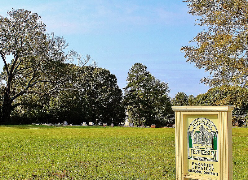
Jefferson, Georgia

Aerial View Of Jefferson, (circa 1950's)
The City of Jefferson's bountiful community has a rich and interesting history. Only an hour's drive from Atlanta, Jefferson was designated the county seat of Jackson County on November 24, 1806. The city, named for President Thomas Jefferson, was the site of a previous Indian settlement named Thomoccoggan. The city was then incorporated as Jeffersonville. Later, the name was changed to Jeffersonton and finally shortened to its current name on June 30, 1824. Dr. Crawford W. Long first used ether for surgery in Jefferson on March 30, 1842. Gently rolling hills and picturesque buildings provide the backdrop for this inviting city. The City's leadership is working to maintain Jefferson's small town character while strongly encouraging the development of new industries to employ the growing local workforce.

A Postcard View of The Martin Institute
Jefferson is a city in Jackson County, Georgia, United States. The population was 3,825 at the 2000 census. The city is the county seat of Jackson County. Jefferson is known for its superior recreation department. Jefferson Parks and Recreation was awarded the class "C" department of the year in 2006.
 Washington St. Jefferson, GA
 Jackson County History
On February 11, 1796, Jackson County was split off from part of Franklin County, Georgia. The new county was named in honor of Revolutionary War Lieutenant Colonel, Congressman, Senator and Governor James Jackson. The county originally covered an area of approximately 1,800 sq mi (4,662 km²), with Clarkesboro as its first county seat.

View of Jefferson downtown square looking north towards the Jackson County Courthouse
In 1801, the Georgia General Assembly granted 40,000 acres (160 km²) of land in Jackson County for a state college. Franklin College (now University of Georgia) began classes the same year, and the city of Athens was developed around the school. Also the same year, a new county was developed around the new college town, and Jackson lost territory to the new Clarke. The county seat was moved to an old Indian village called Thomocoggan, a location with ample water supply from Curry Creek and four large springs. In 1804, the city was renamed Jefferson, after Thomas Jefferson.

The Northside Of Public Square (circa 1910) same view as below

View of the north side of the square. (circa 2007)
Jackson lost more territory in 1811 in the creation of Madison County, in 1818 in the creation of Walton, Gwinnett, and Hall counties, in 1858 in the creation of Banks County, and in 1914 in the creation of Barrow County.

View of the south east side of the square with shops and parking.
The first county courthouse, a log and wooden frame building with an attached jail, was built on south side of the public square; a second, larger, two-story brick courthouse with a separate jailhouse was built in 1817. In 1880, a third was built on a hill north of the square. This courthouse was the oldest continuously operating courthouse in the United States until 2004, when the current courthouse was constructed north of Jefferson.

View of Main Street, If you turn left past the Firestation you will be on the Athens Highway. And if you kept straight you could go to Winder or Braselton.
Pendergrass Store

Pendergrass Store (Jefferson, Ga.)
Located at: Northwest corner of Sycamore and College Streets, Jefferson, Ga.
Two-story wood frame building with a basement, featuring a two-story portico with pediment supported by square Doric inspired columns. The building has one large room on each floor with service rooms in the rear. Soldiers used the upper story as a barracks. After 1936, the wood shingle roof was changed to composition, the wood floor was changed to concrete, and the stuccoed brick foundation was changed to stone.
Date of structure: 1858.
Demographics

View towards the east side of the square showing the Confederate Memorial and the highway leading to Commerce, Georgia. This photo shows the Confederate Memorial in the median commemorating the American Civil War and the Crawford Long Museum can be seen in the background to the left. This highway connects Jefferson with Commerce, Georgia.

Downtown Jefferson, The Bank was on the right corner of the Square.
As of the census of 2000, there were 3,825 people, 1,415 households, and 1,047 families residing in the city. The population density was 201.6 people per square mile (77.8/km²). There were 1,522 housing units at an average density of 80.2/sq mi (31.0/km²). The racial makeup of the city was 80.44% White, 16.05% African American, 1.20% Asian, 1.15% from other races, and 1.15% from two or more races. Hispanic or Latino of any race were 4.21% of the population.

Jackson County Courthouse in Jefferson. GA
There were 1,415 households out of which 37.2% had children under the age of 18 living with them, 55.0% were married couples living together, 15.6% had a female householder with no husband present, and 26.0% were non-families. 23.3% of all households were made up of individuals and 9.2% had someone living alone who was 65 years of age or older. The average household size was 2.67 and the average family size was 3.15.

The Old Harrison Hotel, torn down and replaced with the Crawford W. Long Motel.
In the city the population was spread out with 28.1% under the age of 18, 8.0% from 18 to 24, 30.1% from 25 to 44, 21.4% from 45 to 64, and 12.5% who were 65 years of age or older. The median age was 35 years. For every 100 females there were 88.7 males. For every 100 females age 18 and over, there were 84.0 males.

Aerial View of Graveyard, behind Ford Dealership
The median income for a household in the city was $41,146, and the median income for a family was $46,755. Males had a median income of $33,512 versus $25,250 for females. The per capita income for the city was $18,456. About 12.5% of families and 15.2% of the population were below the poverty line, including 21.8% of those under age 18 and 10.8% of those age 65 or over.

Bridge Over Curry Creek
Growth over the last 6 years has been incredible in the City of Jefferson. The overall population has grown 59% from 2000 to 2006 (6,456)

Marlowe's Cafe, this was one of the best places to eat in the 40's and 50's
Education

Etheridge-Stanton House (Jefferson, Ga.)
Located at: 186 Lee Street, Jefferson, Ga.
Two story wood frame house with two brick end chimneys on a stone foundation. The two-story high porch roof is supported by square Doric inspired columns. A Chinese-Chippendale lattice-type railing on the balcony over the entrance distinguishes the house. The original wood shingled roof was covered with metal before 1937 and recovered with composition shingles after 1937. The house was moved from 178 Lee Street and the brick chimneys were topped with concrete units before 1936. After 1937, the porch floor was converted to concrete, the column bases were converted to brick, and the house was covered with asbestos siding. Stanton purchased the house from Etheridge who lived next door.
Date of structure: 1836.

Presbyterian Church (Jefferson, Ga.)
Located at: 243 Washington Street, Jefferson, Ga.
According to Mr. J. C. Turner, at one time jointly owned by the Presbyterians and the Baptists, each of whom conducted services on alternate Sundays. It was built sometime prior to 1860. The frame church has clapboarding and a gable roof with classic pediment. The porch is recessed and has round wooden fluted columns. The gallery, removed after the Civil War, was replaced in 1972, and the spire was removed in the 1940s because of a lightning strike.
Date of structure: 1840.
Crawford W. Long

Crawford Long was a pioneering physician who is credited with discovering anesthesia.
Jackson County Courthouse

Photograph of the Jackson County Courthouse in Jefferson, Georgia. Cooper Carry Architecture designed this building in the Classical Modern style. Six white columns support a pediment sitting above the entrance to the courthouse. Completed in 2004, this is the county's fifth courthouse.
Jackson County School District
The Jackson County School District holds grades pre-school to grade twelve, that consists of eight elementary schools, three middle schools, two high schools, and an alternative school. The district has 345 full-time teachers and over 5,472 students.
Benton Elementary School
East Jackson Elementary School
Gum Springs Elementary School
Maysville Elementary School
North Jackson Elementary School
South Jackson Elementary School
West Jackson Intermediate School
West Jackson Primary School
East Jackson Middle School
Kings Bridge Middle School
West Jackson Middle School
East Jackson Comprehensive High School
Jackson County High School
Regional Evening Alternative School
Jefferson City School District
The Jefferson City School District holds grades kindergarten to grade twelve, that consists of two elementary schools, a middle school, and a high school. The district has 115 full-time teachers and over 1,525 students.
Jefferson Academy
Jefferson Elementary School
Jefferson Middle School
Jefferson High School
External links
City of Jefferson Website
City of Jefferson Parks & Recreation Website
The Jackson Herald - Local Newspaper
The Preserve at Jefferson - Fountainhead Neighborhood Website
Digitial Library Of Georgia
Subscribe to:
Posts (Atom)

