
The Seven Natural Wonders of Georgia are the most physically
spectacular or unusual sites in the state. These landscape formations
resulted from powerful forces of nature during geologic time—probably
more than 60,000,000 years ago—and, with the exception of Providence
Canyon, predate human activity in Georgia.
The first list of natural wonders was compiled by the state librarian, Ella May Thornton, in response to an inquiry by a journalist. Her list, which appeared in the Atlanta Georgian magazine on December 26, 1926, included Stone Mountain, Okefenokee Swamp, Amicalola Falls, Tallulah Gorge, Warm Springs, Jekyll Island Forest, and the marble vein in Longswamp Valley in Pickens County. Thornton acknowledged that some items on her list were arguable and "there are a number of others of equal rank." Two that she selected and that the Atlanta Georgian described—Jekyll Island Forest ("wild life flourishes there almost as it did before the white men came") and marble deposits in Pickens County ("the largest single vein of marble known to the world")—have not made recent lists.
Two later lists of Georgia's natural wonders appeared in Georgia Voyager magazine in 1997 and in the Atlanta Journal-Constitution in 2001. The generally recognized Seven Natural Wonders are briefly described below in alphabetical order.

Amicalola Falls near Dawsonville are the highest waterfalls in Georgia, with a drop of 729 feet. Named by Cherokee Indians for "tumbling waters," the falls are now the site of one of Georgia's most popular state parks, which includes an overlook at the top of the falls. An eight-mile "approach trail" links the falls to the southern terminus of the Appalachian Trail.

The Okefenokee Swamp is the most extensive of Georgia's natural wonders in terms of area. This wildlife refuge in southeastern Georgia covers about 700 square miles and makes up part of four counties. The Okefenokee (from the Seminole, meaning "land of trembling earth") includes a wide variety of ecological features, ranging from sandy ridges to wet, grassy savannahs and marshes to narrow water channels and small islands, all of which support a vast range of flora and fauna.
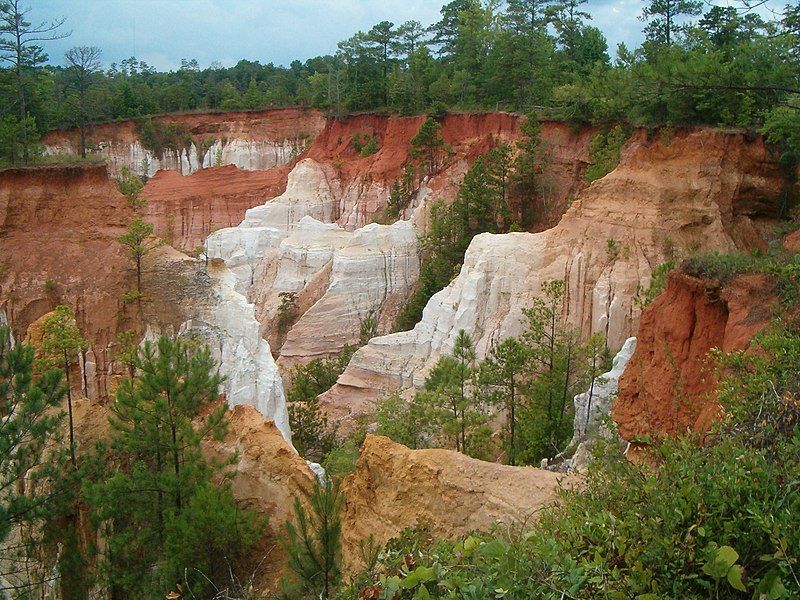
Providence Canyon, sometimes called "Georgia's Little Grand Canyon," is located near Lumpkin in the west central part of the state. The multicolored 1,109-acre network of gorges is more than 100 feet deep. Providence Canyon is unique as a natural wonder of Georgia in that it was caused by relatively recent erosion (from human activity) over the past 150 years.
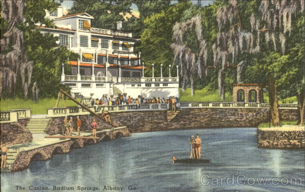
Radium Springs, on the southern outskirts of Albany, has waters that are consistently 68 degrees, rushing from the earth at 70,000 gallons per minute. These waters, which contain traces of radium, are the largest natural springs in Georgia. Overlooking Radium Springs is a park, featuring nature trails and an observation deck, that is located on the site of a casino that had its heyday in the 1920's. The casino was demolished in 2003 after sustaining serious damage when the Flint River flooded in 1994 and 1998.

Stone Mountain, in metropolitan Atlanta, is perhaps the best known of Georgia's natural wonders. A granite dome rising 650 feet above the Piedmont plateau, Stone Mountain is about 2 miles long and 7 miles in circumference at its base. On the northeastern wall is a Confederate memorial conceived in 1914 and completed in 1970. As early as 1927, the DeKalb County Chamber of Commerce proclaimed Stone Mountain to be the "Eighth Wonder of the World," in reference to the original second-century B.C. list of "Seven Wonders of the World," ancient architectural masterpieces.

The Tallulah Gorge in northeast Georgia is a canyon formation 3 miles long and 1,200 feet deep. It was created by a series of waterfalls that were dammed by the Georgia Power Company in 1912. Named after a Native American word for "terrible," Tallulah Gorge was traditionally feared as a home for evil spirits. It was among the most visited tourist destinations in the state in the late nineteenth and early twentieth centuries.
Warm Springs, located on the lower slopes of Pine Mountain in Meriwether County, has long been known for its healing waters. Native Americans used to bring their wounded warriors to the springs, which have a year-round temperature of 88 degrees. A natural trap, about 2,800 feet underground, heats the water. In the antebellum period a minor resort developed at the springs, later made world-famous by U.S. president Franklin D. Roosevelt. Roosevelt found relief there for his polio from the mid-1920's until his death at the Little White House, his home at Warm Springs, in 1945.
Source: georgiaencyclopedia.org
The first list of natural wonders was compiled by the state librarian, Ella May Thornton, in response to an inquiry by a journalist. Her list, which appeared in the Atlanta Georgian magazine on December 26, 1926, included Stone Mountain, Okefenokee Swamp, Amicalola Falls, Tallulah Gorge, Warm Springs, Jekyll Island Forest, and the marble vein in Longswamp Valley in Pickens County. Thornton acknowledged that some items on her list were arguable and "there are a number of others of equal rank." Two that she selected and that the Atlanta Georgian described—Jekyll Island Forest ("wild life flourishes there almost as it did before the white men came") and marble deposits in Pickens County ("the largest single vein of marble known to the world")—have not made recent lists.
Two later lists of Georgia's natural wonders appeared in Georgia Voyager magazine in 1997 and in the Atlanta Journal-Constitution in 2001. The generally recognized Seven Natural Wonders are briefly described below in alphabetical order.
Amicalola Falls near Dawsonville are the highest waterfalls in Georgia, with a drop of 729 feet. Named by Cherokee Indians for "tumbling waters," the falls are now the site of one of Georgia's most popular state parks, which includes an overlook at the top of the falls. An eight-mile "approach trail" links the falls to the southern terminus of the Appalachian Trail.
The Okefenokee Swamp is the most extensive of Georgia's natural wonders in terms of area. This wildlife refuge in southeastern Georgia covers about 700 square miles and makes up part of four counties. The Okefenokee (from the Seminole, meaning "land of trembling earth") includes a wide variety of ecological features, ranging from sandy ridges to wet, grassy savannahs and marshes to narrow water channels and small islands, all of which support a vast range of flora and fauna.
Providence Canyon, sometimes called "Georgia's Little Grand Canyon," is located near Lumpkin in the west central part of the state. The multicolored 1,109-acre network of gorges is more than 100 feet deep. Providence Canyon is unique as a natural wonder of Georgia in that it was caused by relatively recent erosion (from human activity) over the past 150 years.
Radium Springs, on the southern outskirts of Albany, has waters that are consistently 68 degrees, rushing from the earth at 70,000 gallons per minute. These waters, which contain traces of radium, are the largest natural springs in Georgia. Overlooking Radium Springs is a park, featuring nature trails and an observation deck, that is located on the site of a casino that had its heyday in the 1920's. The casino was demolished in 2003 after sustaining serious damage when the Flint River flooded in 1994 and 1998.
Stone Mountain, in metropolitan Atlanta, is perhaps the best known of Georgia's natural wonders. A granite dome rising 650 feet above the Piedmont plateau, Stone Mountain is about 2 miles long and 7 miles in circumference at its base. On the northeastern wall is a Confederate memorial conceived in 1914 and completed in 1970. As early as 1927, the DeKalb County Chamber of Commerce proclaimed Stone Mountain to be the "Eighth Wonder of the World," in reference to the original second-century B.C. list of "Seven Wonders of the World," ancient architectural masterpieces.
The Tallulah Gorge in northeast Georgia is a canyon formation 3 miles long and 1,200 feet deep. It was created by a series of waterfalls that were dammed by the Georgia Power Company in 1912. Named after a Native American word for "terrible," Tallulah Gorge was traditionally feared as a home for evil spirits. It was among the most visited tourist destinations in the state in the late nineteenth and early twentieth centuries.
Warm Springs, located on the lower slopes of Pine Mountain in Meriwether County, has long been known for its healing waters. Native Americans used to bring their wounded warriors to the springs, which have a year-round temperature of 88 degrees. A natural trap, about 2,800 feet underground, heats the water. In the antebellum period a minor resort developed at the springs, later made world-famous by U.S. president Franklin D. Roosevelt. Roosevelt found relief there for his polio from the mid-1920's until his death at the Little White House, his home at Warm Springs, in 1945.
Source: georgiaencyclopedia.org

